When considering planting a garden, you need to know what USDA Hardiness Zone is Alabama for Plants? This article gives you the information you need to know including the USDA Plant Hardiness Zones, climate/rainfall information, and soil types for Alabama.
Alabama, the 22nd state, was admitted to the Union on December 14, 1819. It is located in the southern United States on the Gulf of Mexico and nicknamed the “Heart of Dixie”. It is the 30th largest by area and the 24th-most populous of the U.S. States.
Alabama, like most states fronting the Gulf of Mexico, are at subtropical latitudes between the Gulf of Mexico and the southern end of the flat plains of central North America, which extends from the Arctic Circle to the Gulf of Mexico. Meaning, that the state is exposed to the influences of diverse air masses, including the warm, humid air from the Gulf and dry continental air masses, which are cold in the winter and warm throughout Spring to Fall. Northern portions of Alabama do experience some colder temperatures than those located on the Gulf.
The state of Alabama is bordered in the West by Mississippi, with Georgia to the East, and the Gulf of Mexico to the South near Mobile otherwise Florida is to the south, along with Tennessee to the North.
The US Department of Agriculture designates different plant hardiness zones based on the region and climate of the state. Use these plant hardiness or gardening zones as a reference to better understand what species of plants to grow . Each gardening zone is based primarily on the average lowest temperatures in each specific zone.
If you are wondering what USDA Hardiness Zone is Alabama for plants? , then you are in the right place!
Perennials vs. Annual Plants
Perennial plants regrow every spring, while annual plants live for only one growing season, and then die off. Perennials generally have a shorter blooming period compared to annuals. So, it’s common for gardeners to use a combination of both plants in their yard.
Understanding the USDA Plant Hardiness Zone, the climate, and soil types, amongst other factors, gives a gardener the information for a successful vegetable and/or flower garden. Review this article and prepare to do just that.
USDA Plant Hardiness Zones
The USDA (United States Department of Agriculture) has established different plant hardiness zones (USDA planting zones) throughout the United States. The following image shows the USDA Hardiness Zone maps for the entire country, the South-Central region, and the state of Mississippi:
USDA Plant Hardiness Zones for the USA
The map below shows the new and improved hardiness zones for all states in the country.
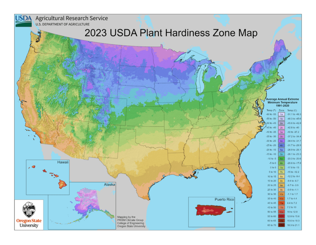
USDA PLANT HARDINESS ZONES FOR USA
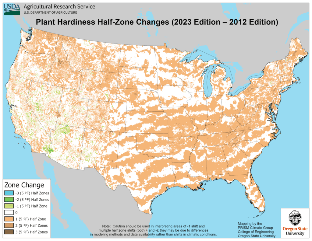
The following USDA map shows the difference between the 2012 and the 2023 versions of the plant hardiness zones.
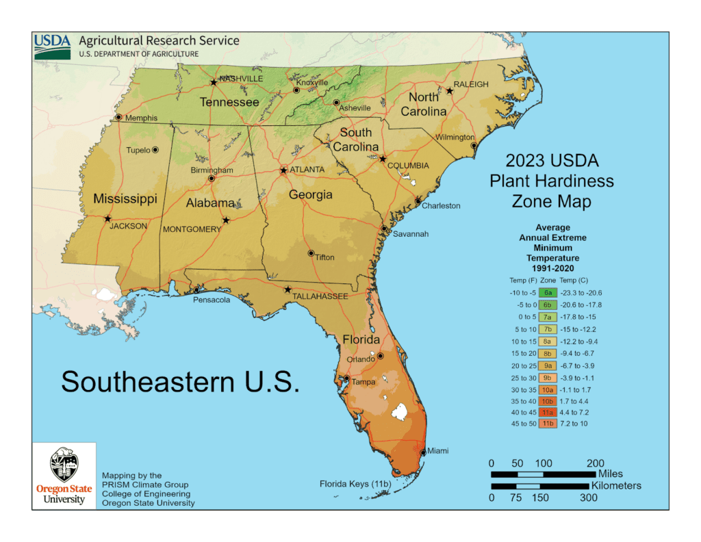
USDA Plant Hardiness Zones for the Southeastern Region
The Plant Hardiness maps for the Southeastern region include the states of Tennessee, North Carolina, South Carolina, Mississippi, Alabama, Georgia, and Florida.
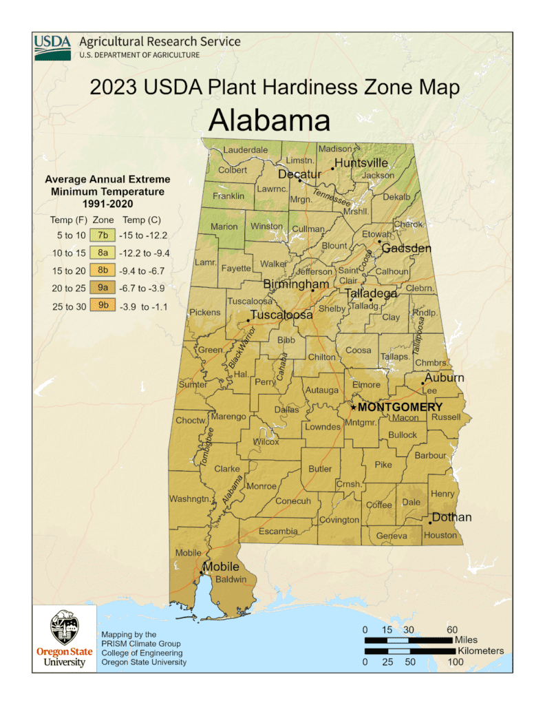
USDA Plant Hardiness Zones for Alabama
The following graphic shows the USDA Hardiness Zone Map for the entire state of Alabama.
Alabama Regions in USDA Plant Hardiness Zones
The state of Alabama contains 67 counties.
There are 5 distinctly different climates and plant hardiness zones in Alabama. These zones range from Zone number 7B to 9B. Differences in the average maximum and minimum temperatures, along with first and last frost dates, are all part of the criteria for each USDA Plant Hardiness Zone. Generally, Alabama sees hot summers and relatively mild winters. However, the top of the state tends to be a bit cooler during the winter.
Gardening is Local
Somebody once said that “gardening is local”. This means that each gardener needs to evaluate their soil, climate, or micro-climate, along with the USDA Plant Hardiness Zone, first and last frost dates, and what plants can be hardy enough to survive the extreme winter temperatures experienced in your specific garden location. In some cases, it may be hard to pinpoint if you are in one zone versus an adjacent zone. Think about your “local” conditions to ensure you have a successful garden.
Far North Alabama (Zone 7B)
Zone 7B is the region at the very top of Alabama. It includes portions of Lauderdale, Colbert, Franklin, Marion, Jackson, and DeKalb counties, among other Counties, and includes small towns such as Waterloo, (Lauderdale County) and Ardmore (in Limestone County). The average annual extreme minimum temperature is 5 to 10 degrees F (degrees Fahrenheit) in USDA Zone 7B.
North Central Alabama (Zone 8A)
Zone 8A represents mostly central northern counties including Marshall, Cherokee, Blount, and Clay among other north central Alabama Counties. Towns include Florence (in Lauderdale County), Decator (in Morgan County), and Anniston (in Calhoun County), among others. The average minimum temperature is 10 to 15 degrees F in USDA Zone 8A.
Lower Central Alabama (Zone 8B)
Zone 8B represents mostly southern counties including Montgomery, Muscogee, Twiggs, and portions of Jefferson and Shelby County, among other southern counties. Towns include much of Birmingham (in Jefferson and Shelby Counties), Montgomery (in Montgomery County), and Phoenix City (in Muscogee County), among others. The average minimum temperature is 15 to 20 degrees F in USDA Zone 7A.
Gulf Coast Alabama (Zone 9A)
Zone 9A represents the far south portions of a few counties directly on the Gulf of Mexico’s coast. These counties include Mobile, Baldwin, and a small portion of Escambia county. Towns include Mobile (in Mobile County) and Gulf Springs (in Baldwin County), among others. The average annual extreme minimum temperature is 20 to 25 degrees F in USDA Zone 9A.
Gulf Coast Alabama (Zone 9B)
Zone 9B represents the farthest south coastal and island portions directly on the Gulf of Mexico’s coast. The average annual extreme minimum temperature is 25 to 30 degrees F in USDA Zone 9A.
Alabama Climate
Climate covers everything from averages to extremes of meteorological variables including temperature and rain. The Koppen climate classification gives information about these climate conditions.
Koppen Climate Classification
Climatologist Wladimir Köppen has classified the entire state of Alabama as having a humid subtropical (Cfa) climate classification. The state’s average annual temperature is 64 °F (18 °C). Temperatures tend to be warmer in the state’s southern portion with its proximity to the Gulf of Mexico, while its northern portions, especially in the Appalachian Mountains in the northeast, tend to experience cooler temperatures. A humid subtropical climate is classified as having a mild climate with a hot summer but no specific dry season. In general, you may expect warm-to-hot summers and cold-to-mild winters. Its growing season is up to 300 days along its southern portion of the state.
Severe weather does have the potential for impacting crops. It does experience thunderstorms year round with occasional hailstorms where high winds and/or hail can damage crops. Alabama is ranks 2nd in the U.S. for the deadliest tornadoes, so tornadoes are a threat. Hurricanes are a threat as well, especially in the more southern portions of the state.
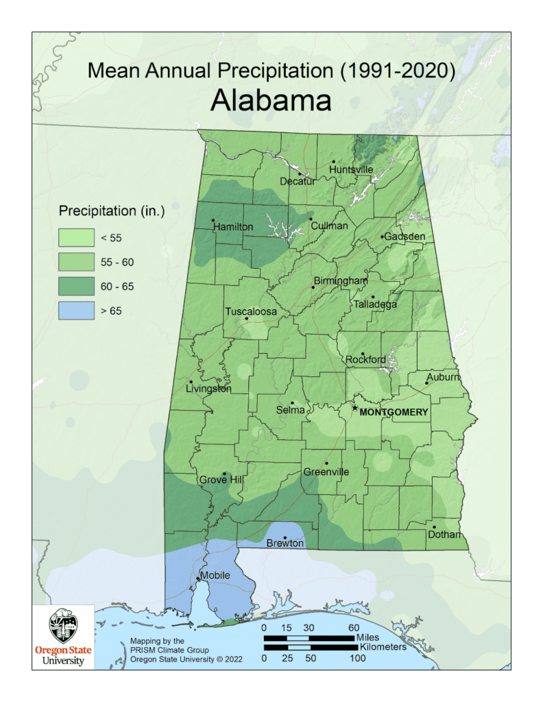
Annual Precipitation
The average annual rainfall for Alabama is 58.23 inches per year which is the fourth wettest state in the U.S. A. The averages do range across the different sub-climates in the state. The rain amounts tend to go up as you go further south especially as you get close to the Gulf Coast portions of the state.
Total measurable snow or sleet of up to 2 inches may fall in the northern portions of the state whereas the Gulf Coast may not see any for years.
What Affects Climate in Mississippi?
Many things affect climate, and micro-climates within local areas as well. It said that gardening is local and that sure applies to Alabama gardens.
General Climate Impacts
Climates generally are affected by:
- Latitude: Temperature range increases with distance from the equator
- Altitude: Temperatures decrease with height as the air is less dense and cannot hold heat as well
- Winds: Winds blown in from a hot area can raise temperatures
- Humidity: Moisture in the air has an impact on how people and plants feel the effects of temperatures.
- Distance from the sea (continentality)
- Exposure: If trees, structures, or other factors cause shade, block the wind, etc.
State Geographical Climate Impacts
Alabama’s generally warm, humid climate results from its mid-latitude location and proximity to the Gulf of Mexico. This location, like others along the Gulf Coast, produces the often-turbulent weather patterns that regularly bring tornadoes and hurricanes to the state. Alabama’s climate has relatively mild winters, hot summers, and year-round precipitation.
All of these factors come into play in understanding the climate and ultimately, the plant hardiness zones and whether a plant will survive as a perennial or annual.
First and Last Frost
The only real factor that matters when determining the USDA growing zone of a region is its extreme temperature lows. Compare the average annual minimum winter temperature to the temperature requirements of your plants or seeds to determine if it is a good fit for your climate. That’s the first step.
The second step is to determine your particular area’s first and last frost date projections based on your city name or Zip Code. There are many sites to check this such as the Farmer’s Almanac.
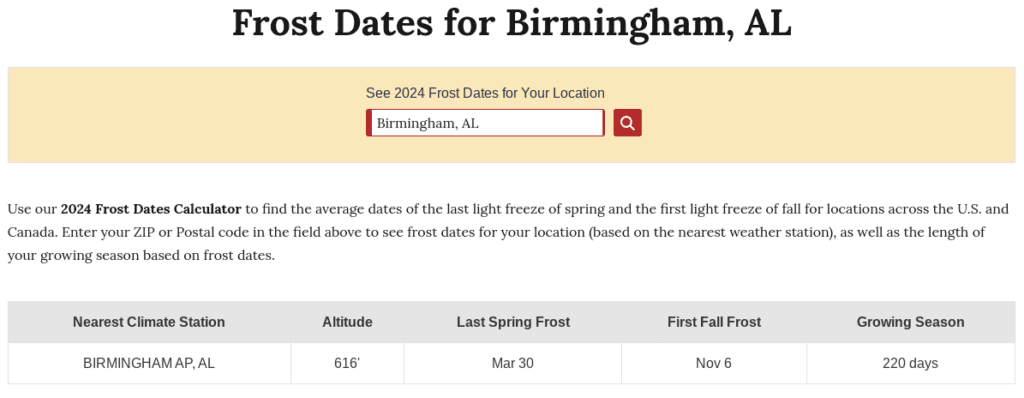
Next is a determination, if an annual, as to when you can plant the plant or sow the seed based on the first and last frost date, along with time to maturity. For example, the latest sow date for a plant that gets to maturity in 70 days, must be sowed at least 70 days before the first Fall freeze date to get a harvest in before the plant is damaged by the first frost. Conversely, you do not want to plant a seedling or sow seed before the last expected frost date in the late Winter or early Spring.
An important concept is to understand the projected first and last frost dates are merely a projection based on historical climate data. The example above by the Farmer’s Almanac uses a 30% probability factor when determining the projected dates. That means there is some limited risk with planting out seedlings in your garden based on this date as Mother Nature will decide if it wants to follow these dates or not.
Growing Seasons
The growing season represents what portion of the year you can grow. It refers to the number of days between the last frost of the Spring and the first frost of the Fall. This is the part of the year when the weather conditions are conducive to good plant growth based on temperatures and rainfall. Mississippi, due to its climate, has a long growing season.
The growing season in Alabama differentiates between the different USDA Plant Hardiness Zones. For example, Birmingham’s growing season, per the Farmer’s Almanac, is 220 days , which is based on the last spring frost and the first Fall frost. Decatur’s growing season is 213 days, while Mobile’s growing season is 269 days. Your zones in the southern portions of the state are going to experience a longer growing system than those in the North, but generally around 205 days for the state.
Gardening in Alabama is very much a year-round affair, regardless of the climate. There are hardy plants, perennials, and annuals that do well even in the coldest or hottest months of the year. There are several perennials, especially native plants, that can grow and thrive year after year.
Soil Types in Alabama
In Alabama, there are several major soil resource areas. The predominant soils and composite vegetation define major ecoregions across the state. Soil types in Alabama include Limestone Valleys and Uplands, Appalachian Plateau, Piedmont Plateau, Coastal Plane, Blackland Prairie, Major FloodPlains and Terraces, and Coastal Marshes and Beaches..
Limestone Valleys and Uplands
Weathered limestone with some red clayey soils with silt loam textures were deposited over the years in these regions. This includes land in the Lauderdale, Limestone and Madison Counties up north and pockets distributed throughout Etowah, Blount, Cherokee, Calhoun, and Talladega counties, among others, around the Tennessee and Coosa river valleys. Topography is general level to undulating and elevations are about 600 feet. A majority of the land is open and primary crops in these areas include cotton or soybean.
Appalachian Plateau
The major component of the soils found on Cumberland, Sand, Lookout, Cuntie Brindlee, Chandler, and other smaller mountains, are sandstone and shale. The more level areas were formed from weathered sandstone, with loamy subsoils and fine sandy loam surface layers. These small mountains generally have slopes less than 10%. Elevation of the small mountains are about 1,300 feet. Primary crops in the small mountain areas include corn, soybeans, potatoes, and tomatoes. Poultry farms also utilize these areas.
Shale, with a clayey subsoil and silt loam surface layers makes up the rugged sections of the mountains in Alabama. Elevations range from 300 to 700 feet with slopes too steep for crops.
Piedmont Plateau
The Piedmont Plateau contains soils mainly derived from granite, homblende, and mica schists. This includes red clayey subsoils and sandy loam or clay loam surface layers. The topography of the mountains on the Piedmont Plateau are generally rolling to steep with elevations from 700 to 1000 feet, with higher elevations ranging from 900 to 2407 feel along the Talladega Hills.
Coastal Plain
Marine and fluvial sediments eroded from the Piedmont and Appalachian plateaus make up the soils present in the Coastal Plain.
The Upper Coastal Plains have either a loamy subsoil and sandy loam or loamy sand surface layers. Primary crops in the Upper Coastal Plains are corn, peanuts, soybeans, and horticultural crops. Timber products and hogs are important resources in this area as well.
Blackland Prairie
The soils in the Blackland Prairie were derived from alkaline, Selma chalk, or acid marine clays. Both Acidic and Alkaline soils are distributed throughout the area. The area is level to undulating topography with elevation around 200 feet. The primary crop for this area is soybeans. Timber production and pastures make up the majority of this area..
The Blackland Prairie covers an area from the west central to the east central portion of the state going through the central part of the state. This center area is sometimes called the “Black Belt” due to the dark color of the soils throughout the area.
Major FloodPlains and Terraces
The floodplains and terraces are found along streams and rivers that deposit alluvium (clay, silt, and gravel) along the rivers, riverbanks, and the floodplains during floods. It’s typical to see crops grown on the level terraces while the floodplains are bottomland hardwood forests.
Coastal Marshes and Beaches
Coastal Marshes and Beaches are present in a few locations in the bottom southwest portion of the state north of Mobile Bay and around Dauphin Island and Gulf Shores area along the coast. These are areas of nearly level and level bottomlands, along with tidal flats, and beaches. These soils are generally deep and very poorly drained with dark grayish, brown, muck surfaces over a blackish muck on top of brownish sand. Their elevation is from sea level to a few feet above sea level.
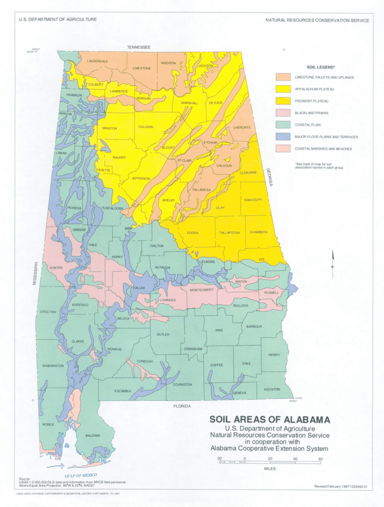
It is important to understand the local garden’s soil type, especially if using conventional rows or soil that’s in-ground. If you have never checked, it’s a good idea to get your soil analyzed to understand what amendments may be needed.
The Auburn University Soil Testing Laboratory offers a program where samples can be submitted and a report of the soil analysis and recommendations is offered. Soil sample boxes are available for Alabama residents at their local Alabama Extension Service offices located in each county (https://www.aces.edu/counties/).
The soil analysis program has more value for those backyard gardeners using in-ground soil. There are a variety of well-balanced raised bed soil mixes available commercially or a prescriptive soil mix that can be put together DIY-style such as Mel’s Mix (made famous from Square Foot Gardening).
The Right Plants for Alabama and Your Zone
Selection of Plants
Selection of each particular plant is an exercise of understanding the seeds or seedlings you may be purchasing and which Zones are recommended. You can usually find this on the back of a seed packet or a plant’s label. If purchasing plants or seedlings from a local plant nursery, you can generally assume that they offer plants suitable for the plant hardiness zones in that area. Purchasing from a big box store may need a little bit more scrutiny.
Perennial Plants
As for perennial plants, one of the best sources is to identify the native plants found in and around the local area. These native plant species are tested and proven to be hardy plants or they would not be long-lasting or considered native to the area. Many perennial plants are knocked back when there is a hard freeze. However, they will come back next Spring.
Hot and Cold Impact on Plants
One would think looking at the USDA Plant Hardiness zones, that the coldest extreme temperatures are the only consideration for hardy plants. However, some warmer areas with extreme summer heat also have a significant impact on what plants will thrive, including trees, shrubs, ground cover, etc.
Alabama’s hot summer climate may tempt you to select plants that are more accustomed to drier or more drought-like climates. This would not be a good choice as most plants adapted to a dry climate will eventually rot and die during periods of heavy rainfall that portions of Alabama’s climate tend to experience.
USDA Plant Hardiness Zones for Alabama Major Cities
The USDA Plant Hardiness Zone is:
- Auburn (8B)
- Birmingham (8A/8B)
- Decatur (8A)
- Dothan (9A)
- Huntsville (7B/8A)
- Madison (8A/8B)
- Montgomery (8B)
- Mobile (9A)
- Hoover (8A/8B)
- Talladega (8A)
- Tuscaloosa (8B)
Conclusion
What USDA Hardiness Zone is Alabama for plants?
The state of Alabama has 5 separate U.S. Department of Agriculture Plant Hardiness Zones starting at 7B at the very top of the state down to 9B at the extreme coastal regions of the state. These plant hardiness or growing zones are used as a reference for gardeners to better understand what species of plant can be grown successfully, either as an annual or perennial, in each plant zone.
Alabama, with its warm, humid climate, gives us gardeners a long season to grow and harvest our favorite crops from our vegetable garden. Remember which USDA Hardiness Zone is Alabama is important to picking the right plants or seeds and having gardening success.
If you like this content, make sure you check out my 7 Reasons to Start a Garden or my Seeding Square Template post. Also, I’m sure you will enjoy checking out my Louisiana Simple Living YouTube channel where I focus videos on teaching about raised bed gardens and achieving bountiful harvests.

Leave a Reply